Check out our new promotional film for Guesstimate, a Geogame developed in cooperation with ESRI.
Get more information in our post about Guesstimate.
Check out our new promotional film for Guesstimate, a Geogame developed in cooperation with ESRI.
Get more information in our post about Guesstimate.
Olga Yanenko, member of the Geogames team, gave a lightning talk in this year’s DevSummit taking place March 10-13 at the Palm Springs Convention Center.
Have a look at her prezi!
Where you think you are, is not where you might end up playing this game! Guesstimate is a casual game that uitilizes algorithms typically used for GPS positioning and provides you a random exploration experience of your city.
Knowing about your distance to predefined locations around you allows you to compute your current position. Of course, this task gets more difficult by 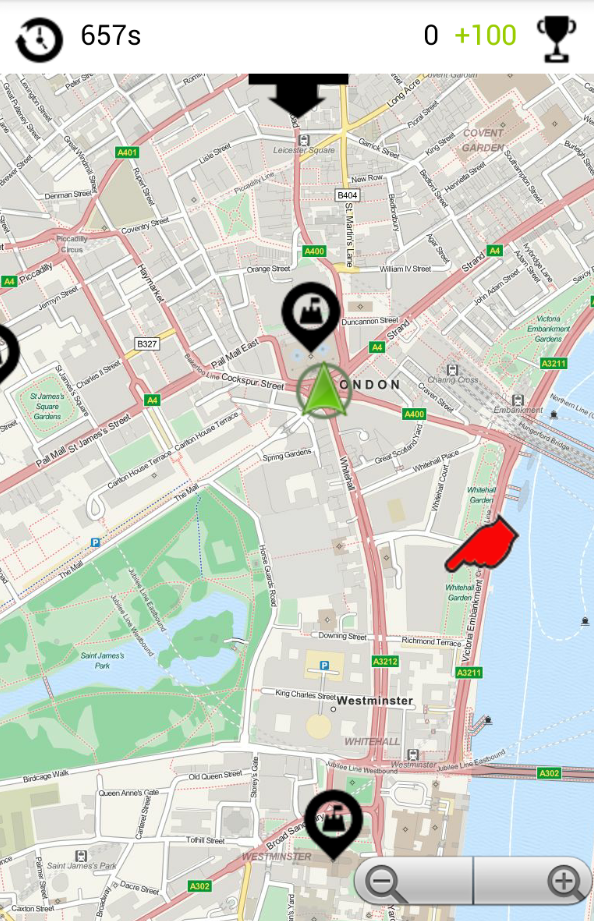 measurement errors. Guesstimate illustrates the impact of such errors by handing the job of delivering reliable distance measurements over to you: How far is it from your current position to e.g. Big Ben, Westminster Abbey or Tower Bridge? From your guesses, Guesstimate derives a geocoordinate where you would be, if your estimations were correct. Before the next round starts, you have to move to that place as a penalty – the better you guess, the less you walk…
Give it a try (just download the file on your Android device and tap once to install):
http://www.geogames-team.org/files/Guesstimate.apk
Got noone staging a game for you? Design your own gameboard with only a few taps on your mobile:
http://www.geogames-team.org/guesstimate/editor/
Thanks again to ESRI for making this possible.
As an outcome of the Geogames and Playful Geodesign project funded by ESRI, a new game is available. Equilibrium tells you a lesson about population dynamics.
Have a look at the demo video:
Interested? Drop us a line: geogames[at]uni-bamberg.de
The Geogames team of the University of Bamberg is present at the ESRI Europe, Middle East and Africa Education GIS Conference. The conference takes place on October 22nd and 23rd at the ICM Munich. An Unconference Session about Geogames organized by the team on Tuesday, Oktober 22nd.
Christoph Schlieder, head of the Geogames team, talks at the 2013 Geodesign Summit Europe. A Geogaming session is organized at the European Geodesign Summit 2013 held on September 19th and 20th in GeoFort, Herwijnen, Netherlands. The session will takes place on Thursday, September 19th in the Kadaster Room.
Dominik Kremer, member of the Geogames team is going to participate in this year’s Education GIS Conference held July 8th to 12th in San Diego, CA. Besides a presentation with the title “Learning to Understand Geodesigns by Playing Geogames” there will be a demonstration of the Geogame CityPoker developed at the University of Bamberg several years ago.
Olga Yanenko, member of the Geogames team, is going to participate in this year’s DevSummit taking place March 25-28 at the Palm Springs Convention Center. One of the objectives of this visit will be to explore the possibilities of GIS and related technologies for the development of mobile location-based applications. Another aspect is focused on location-based services and gamification research in general as well as networking activities to strengthen the interconnection of researchers and developers in this special area.

Olga Yanenko, member of the Geogames team, is spending four weeks in the ESRI Applications Prototype Lab (APL) in Redlands, CA. This visit aims the exchange of knowledge between the Geogames team and the APL developers.
Christoph Schlieder, the head of the Geogames team, talks at the 2013 Geodesign Summit. The players of a Geogame explore an outdoor environment and use GPS enabled smartphones to solve documentation tasks and access spatial information. These games are particularly interesting for educational projects on Geodesign because they not only connect the players socially but also connect them with the geographic environment.

Geogames Team
University of Bamberg
Christoph Schlieder
(Scientific Responsible)

ESRI Education Team
Michael Gould (Responsible)